Category Archives: Economic geography

Spatial economics JMPs (2020-2021)

Here’s a list of job-market candidates whose job-market papers fall within spatial economics, as defined by me quickly skimming webpages. I’m sure I missed folks, so please add them in the comments.

Of the 27 candidates I’ve initially listed, 12 registered a custom domain, 8 used Google Sites, 3 used GitHub, 3 used school-provided webspace, and 2 used Weebly.

Here’s a cloud of the words that appear in these papers’ titles:

Aaron Weisbrod (Brown) – Housing Booms and Urban Frictions: The Impact of the 1917 Halifax Explosion on Local Property Values
Aleksandar Petreski (Jönköping University, Sweden)
Spatial-temporal asymmetry, shock and memory: housing transaction prices in Sweden
Andrew Simon (Michigan) – Public Good Spillovers and Fiscal Centralization: Evidence from Community College Expansions
Avichal Mahajan (Geneva) – Highways and segregation
Björn Brey (Nottingham) – The long-run gains from the early adoption of electricity
Brendan Shanks (LMU Munich) – Land Use Regulations and Housing Development: Evidence from Tax Parcels and Zoning Bylaws in Massachusetts
Christoph Albert (CEMFI) – Immigration and Spatial Equilibrium: the Role of Expenditures in the Country of Origin
Desen Lin (Penn) – Housing Search and Rental Market Intermediation
Dmitry Sedov (Northwestern) – How Efficient are Firm Location Configurations? Empirical Evidence from the Food Service Industry
Eduardo Fraga (Yale) – Drivers of Concentration: The Roles of Trade Access, Structural Transformation, and Local Fundamentals
Eunjee Kwon (USC) – Why Do Improvements in Transportation Infrastructure Reduce the Gender Gap in South Korea?
Ewane Theophile (UQAM) – Trade costs, prices and connectivity in Rwanda
Ezequiel Garcia-Lembergman (Berkeley) – Multi-establishment Firms, Pricing and the Propagation of Local Shocks: Evidence from US Retail
Franklin Qian (Stanford) – The Effects of High-skilled Firm Entry on Incumbent Residents
Gregor Schubert (HBS) – House Price Contagion and U.S. City Migration Networks
Ian Herzog (Toronto) – The City-Wide Effects of Tolling Downtown Drivers: Evidence from London’s Congestion Charge
Jacob Krimmel (Wharton) – Reclaiming Local Control: School Finance Reforms and Housing Supply Restrictions
Jan David Bakker (UCL) – Trade and Agglomeration: Theory and Evidence from France
Joanna Venator (Wisconsin) – Dual Earner Migration, Earnings, and Unemployment Insurance
John Pedersen (Binghamton) – Voting for Transit: The Labor Impact of Public Transportation Improvements
Jonathan Moreno-Medina (Duke) – Local Crime News Bias and Housing Markets
Kate Pennington (Berkeley ARE) – Does Building New Housing Cause Displacement?: The Supply and Demand Effects of Construction in San Francisco
Kenneth Tester (Kentucky) – The Effect of Taxes on Where Superstars Work
Magdalena Domínguez (Barcelona) – Sweeping Up Gangs: The Effects of Tough-on-crime Policies from a Network Approach
Marcos Ribeiro Frazao (Yale) – Brand Contagion: The Popularity of New Products in the United States
Margaret Bock (WVU) – Unintended Consequences of the Appalachian Development Highway System on Mortality
Mariya Shappo (Illinois) – The Long-Term Impact of Oil and Gas Extraction: Evidence from the Housing Market
Matthew Gross (Michigan) – The Long-Term Impacts of Rent Control on Renters
Meng Li (Queen’s) – Within-city Income Inequality, Residential Sorting, and House Prices
Miguel Zerecero (TSE) – The Birthplace Premium
Pablo E. Warnes (Columbia) – Transport Infrastructure Improvements, Intra-City Migration, and Spatial Sorting: Evidence from a BRT system in Buenos Aires
Pedro Tanure Veloso (Minnesota) – Housing Supply Constraints and the Distribution of Economic Activity: The Case of the Twin Cities
Piyush Panigrahi (Berkeley) – Endogenous Spatial Production Networks: Quantitative Implications for Trade and Productivity
Prottoy Aman Akbar (Pittsburgh) – Who Benefits from Faster Public Transit?
Rizki Nauli Siregar (UC Davis) – Global Prices, Trade Protection, and Internal Migration: Evidence from Indonesia
Sarah Thomaz (UC Irvine) – Investigating ADUS: Determinants of Location and Their Effects on Property Values
Sebastian Ellingsen (Pompeu Fabra) – Free and Protected: Trade and Breaks in Long-Term Persistence
Sebastian Ottinger (UCLA Anderson) – Immigrants, Industries and Path Dependence
Shiyu Cheng (Kentucky) – High-Speed Rail Network and Brain Drain: Evidence from College Admission Scores in China
Sydney Schreiner (Ohio State) – Does Gentrification Stop at the Schoolhouse Door? Evidence from New York City
Tianyun Zhu (Syracuse) – Estimating the Implicit Price Elasticity of the Demand for Neighborhood Amenities: A Hedonic Approach
Tillman Hönig (LSE) – The Legacy of Conflict: Aggregate Evidence from Sierra Leone
Timur Abbiasov (Columbia) – Do Urban Parks Promote Racial Diversity in Social Interactions? Evidence from New York City
Xiao Betty Wang (Wharton) – Housing Market Segmentation
Yiming He (Stanford) – The Economic Impacts of Slum Demolition on the Displaced: Evidence from Victorian England
Zibin Huang (Rochester) – Peer Effects, Parental Migration and Children’s Human Capital: A Spatial Equilibrium Analysis in China

Spatial Economics for Granular Settings

Economists studying spatial connections are excited about a growing body of increasingly fine spatial data. We’re no longer studying country- or city-level aggregates. For example, many folks now leverage satellite data, so that their unit of observation is a pixel, which can be as small as only 30 meters wide. See Donaldson and Storeygaard’s “The View from Above: Applications of Satellite Data in Economics“. Standard administrative data sources like the LEHD publish neighborhood-to-neighborhood commuting matrices. And now “digital exhaust” extracted from the web and smartphones offers a glimpse of behavior not even measured in traditional data sources. Dave Donaldson’s keynote address on “The benefits of new data for measuring the benefits of new transportation infrastructure” at the Urban Economics Association meetings in October highlighted a number of such exciting developments (ship-level port flows, ride-level taxi data, credit-card transactions, etc).

But finer and finer data are not a free lunch. Big datasets bring computational burdens, of course, but more importantly our theoretical tools need to keep up with the data we’re leveraging. Most models of the spatial distribution of economic activity assume that the number of people per place is reasonably large. For example, theoretical results describing space as continuous formally assume a “regular” geography so that every location has positive population. But the US isn’t regular, in that it has plenty of “empty” land: more than 80% of the US population lives on only 3% of its land area. Conventional estimation procedures aren’t necessarily designed for sparse data sets. It’s an open question how well these tools will do when applied to empirical settings that don’t quite satisfy their assumptions.

Felix Tintelnot and I examine one aspect of this challenge in our new paper, “Spatial Economics for Granular Settings“. We look at commuting flows, which are described by a gravity equation in quantitative spatial models. It turns out that the empirical settings we often study are granular: the number of decision-makers is small relative to the number of economic outcomes. For example, there are 4.6 million possible residence-workplace pairings in New York City, but only 2.5 million people who live and work in the city. Applying the law of large numbers may not work well when a model has more parameters than people.

Felix and I introduce a model of a “granular” spatial economy. “Granular” just means that we assume that there are a finite number of individuals rather than an uncountably infinite continuum. This distinction may seem minor, but it turns out that estimated parameters and counterfactual predictions are pretty sensitive to how one handles the granular features of the data. We contrast the conventional approach and granular approach by examining these models’ predictions for changes in commuting flows associated with tract-level employment booms in New York City. When we regress observed changes on predicted changes, our granular model does pretty well (slope about one, intercept about zero). The calibrated-shares approach (trade folks may know this as “exact hat algebra“), which perfectly fits the pre-event data, does not do very well. In more than half of the 78 employment-boom events, its predicted changes are negatively correlated with the observed changes in commuting flows.

The calibrated-shares procedure’s failure to perform well out of sample despite perfectly fitting the in-sample observations may not surprise those who have played around with machine learning. The fundamental concern with applying a continuum model to a granular setting can be illustrated by the finite-sample properties of the multinomial distribution. Suppose that a lottery allocates I independently-and-identically-distributed balls across N urns. An econometrician wants to infer the probability that any ball i is allocated to urn n from observed data. With infinite balls, the observed share of balls in urn n would reveal this probability. In a finite sample, the realized share may differ greatly from the underlying probability. The figure below depicts this ratio for one urn when I balls are distributed across 10 urns uniformly. A procedure that equates observed shares and modeled probabilities needs this ratio to be one. As the histograms reveal, the realized ratio can be far from one even when there are two orders of magnitude more balls than urns. Unfortunately, in many empirical settings in which spatial models are calibrated to match observed shares, the number of balls (commuters) and the number of urns (residence-workplace pairs) are roughly the same. The red histogram suggests that shares and probabilities will often differ substantially in these settings.

Balls and 10 urns: Histogram of realized share divided by underlying probability

Balls and 10 urns: Histogram of realized share divided by underlying probability

Granularity is also a reason for economists to be cautious about their counterfactual exercises. In a granular world, equilibrium outcomes depend in part of the idiosyncratic components of individuals’ choices. Thus, the confidence intervals reported for counterfactual outcomes ought to incorporate uncertainty due to granularity in addition to the usual statistical uncertainty that accompanies estimated parameter values.

See the paper for more details on the theoretical model, estimation procedure, and event-study results. We’re excited about the growing body of fine spatial data used to study economic outcomes for regions, cities, and neighborhoods. Our quantitative model is designed precisely for these applications.

Shift-share designs before Bartik (1991)

The phrase “Bartik (1991)” has become synonymous with the shift-share research designs employed by many economists to investigate a wide range of economic outcomes. As Baum-Snow and Ferreira (2015) describe, “one of the commonest uses of IV estimation in the urban and regional economics literature is to isolate sources of exogenous variation in local labor demand. The commonest instruments for doing so are attributed to Bartik (1991) and Blanchard and Katz (1992).”

The recent literature on the shift-share research design usually starts with Tim Bartik’s 1991 book, Who Benefits from State and Local Economic Development Policies?. Excluding citations of Roy (1951) and Jones (1971), Bartik (1991) is the oldest work cited in Adao, Kolesar, Morales (QJE 2019). The first sentence of Borusyak, Hull, and Jaravel’s abstract says “Many studies use shift-share (or “Bartik”) instruments, which average a set of shocks with exposure share weights.”

But shift-share analysis is much older. A quick search on Google Books turns up a bunch of titles from the 1970s and 1980s like “The Shift-share Technique of Economic Analysis: An Annotated Bibliography” and “Dynamic Shift‐Share Analysis“.

Why the focus on Bartik (1991)? Goldsmith-Pinkham, Sorkin, and Swift, whose paper’s title is “Bartik Instruments: What, When, Why and How”, provide some explanation:

The intellectual history of the Bartik instrument is complicated. The earliest use of a shift-share type decomposition we have found is Perloff (1957, Table 6), which shows that industrial structure predicts the level of income. Freeman (1980) is one of the earliest uses of a shift-share decomposition interpreted as an instrument: it uses the change in industry composition (rather than differential growth rates of industries) as an instrument for labor demand. What is distinctive about Bartik (1991) is that the book not only treats it as an instrument, but also, in the appendix, explicitly discusses the logic in terms of the national component of the growth rates.

I wonder what Tim Bartik would make of that last sentence. His 1991 book is freely available as a PDF from the Upjohn Institute. Here is his description of the instrumental variable in Appendix 4.2:

In this book, only one type of labor demand shifter is used to form instrumental variables2: the share effect from a shift-share analysis of each metropolitan area and year-to-year employment change.3 A shift-share analysis decomposes MSA growth into three components: a national growth component, which calculates what growth would have occurred if all industries in the MSA had grown at the all-industry national average; a share component, which calculates what extra growth would have occurred if each industry in the MSA had grown at that industry’s national average; and a shift component, which calculates the extra growth that occurs because industries grow at different rates locally than they do nationally…

The instrumental variables defined by equations (17) and (18) will differ across MSAs and time due to differences in the national economic performance during the time period of the export industries in which that MSA specializes. The national growth of an industry is a rough proxy for the change in national demand for its products. Thus, these instruments measure changes in national demand for the MSA’s export industries…

Back in Chapter 7, Bartik writes:

The Bradbury, Downs, and Small approach to measuring demand-induced growth is similar to the approach used in this book. Specifically, they used the growth in demand for each metropolitan area’s export industries to predict overall growth for the metropolitan area. That is, they used the share component of a shift-share analysis to predict overall growth.

Hence, endnote 3 of Appendix 4.2 on page 282:

This type of demand shock instrument was previously used in the Bradbury, Downs and Small (1982) book; I discovered their use of this instrument after I had already come up with my approach. Thus, I can only claim the originality of ignorance for my use of this type of instrument.

Tim once tweeted:

Researchers interested in “Bartik instrument” (which is not a name I coined!) might want to look at appendix 4.2, which explains WHY this is a good instrument for local labor demand. I sometimes sense that people cite my book’s instrument without having read this appendix.

Update (10am CT): In response to my query, Tim has posted a tweetstorm describing Bradbury, Downs, and Small (1982).

What’s an “iceberg commuting cost”?

In the recent quantitative spatial economics literature, the phrase “iceberg commuting cost” appears somewhat often. The phrase primarily appears in papers coauthored by Stephen Redding (ARSW 2015, RR 2017, MRR 2018, HRS 2018), but it’s also been adopted by other authors (Fratto 2018, Gaigne et al 2018, Matt Turner’s lecture notes). However, none of these papers explicitly explains the meaning of the phrase. Why are we calling these commuting costs “iceberg”?

The phrase was imported from international economics, where the concept of “iceberg transport costs” is widely used. That idea is also explicitly defined. Alan Deardorff’s glossary says:

A cost of transporting a good that uses up some fraction of the good itself, rather than other resources. By analogy with floating an iceberg, costless except for the part of the iceberg that melts. Far from realistic, but a tractable way of modeling transport costs since it impacts no other market. Due to Samuelson (1954).

Two bits of trivia that aren’t very relevant to the rest of the post: these should be called “grain transport costs” because von Thunen introduced the idea with oxen-pulled grain carts more than a century before Samuelson (1954) and basic physics means there are actually economies of scale in shipping ice.

Why do we use the iceberg assumption? As Deardorff highlights, it lets us skip modeling the transportation sector. By assumption, the same production function that produces the good also produces its delivery to customers. For better or worse, that means that international or long-distance transactions don’t affect factor demands or transport prices by being international or long-distance per se (Matsuyama 2007). This is one way of keeping trade models simple. Per Gene Grossman: “few would consider the ‘iceberg’ formulation of shipping costs as anything more than a useful trick for models with constant demand elasticities.”

In urban economics, saying that commuting costs take the “iceberg” form means that the model abstracts from transportation infrastructure and the transport sector. Commuters “pay” commuting costs by suffering lower utility. There is no supplier of transportation services that earns any revenues. (Given that most US roads are unpriced, this isn’t much of an abstraction.) But, just as folding transportation services into the goods-producing firm’s production function has consequences for trade models, saying that commuting enters the utility function directly has consequences for the economic content of urban models.

Given that these models do not feature a labor-leisure tradeoff, there is an equivalence between utility costs and time costs. As described by Ahfeldt, Redding, Sturm, and Wolf (2015): “Although we model commuting costs in terms of utility, there is an isomorphic formulation in terms of a reduction in effective units of labor, because the iceberg commuting cost enters the indirect utility function (5) below multiplicatively.” If the cost of commuting is mostly about the opportunity cost of time, then this modeling device captures it reasonably well in a model with homogeneous workers.

If workers are heterogeneous in their hourly wages, then their opportunity costs of time differ. Higher-wage workers have higher opportunity costs of time. In the classic model of locational choice (see Kevin Murphy’s lecture), this causes higher-wage workers to be more willing to pay for residential locations that give them shorter commutes. In the typical quantitative spatial model, however, preferences are Cobb-Douglas over housing and a tradable good. As a result, even with heterogeneous agents, the utility-cost and time-cost formulations of commuting costs are equivalent.

But what if commuting costs are paid with money? In addition to more time on the road, driving a greater distance involves burning more fuel. (Actually, in these models, it typically involves burning more of the numeraire good.) This is not equivalent to the utility formulation, because the cost of a tank of gas is not a constant proportion of one’s income. Moreover, if the car itself costs money, then lower-wage workers might take the bus. The monetary costs of accessing different commuting technologies can have big consequences for urban form, as suggested by LeRoy and Sonstelie (1983), Glaeser, Kahn, and Rappaport’s “Why do the poor live in cities?” and Nick Tsivanidis’s paper on bus-rapid transit in Bogota. The iceberg formulation of commuting costs cannot tackle these issues.

Similarly, even though transportation infrastructure is surely more capital-intensive than much of the economy, we cannot speak to that issue when we parsimoniously model transport as simply coming out of people’s utility.

“Iceberg commuting cost” is a short, three-word phrase. I hope the 600+ words above suggest what it might mean.

Spatial economics JMPs (2018-2019)

Last year, I comingled spatial-economics candidates with the trade JMCs. This year, I’m offering a separate list. Thanks to those who suggested spatial-economics candidates in response to my tweet. Since people working on spatial economics come from a variety of fields, I’ve listed candidate’s self-identified fields in brackets after their JMP title. I’m sure I missed folks, so please add them in the comments.

  • Clare-Balboni (LSE) – In Harm’s Way? Infrastructure Investments and the Persistence of Coastal Cities [Environmental, Trade, Development]
  • Chiara Fratto (Chicago) – The reallocative effects of mobility restrictions on workers and firms. An application to the West Bank [applied macro, urban, productivity, trade]
  • Xuan Fei (UC Davis) – Land Market Misallocation in China [International, Urban, Macro, and Chinese Economy]
  • Laurel Wheeler (Duke) – Property Rights, Place-Based Policies, and Economic Development [labor and development]
  • Dennis McWeeny (Wisconsin) – Spatial Competition in the Airline Industry [industrial organization, health, and regional]
  • Yanjun (Penny) Liao (UCSD) – How Hurricanes Sweep Up Housing Markets: Evidence from Florida [Environmental, Public]
  • Xueying Lu (UCSD) – Housing Markets and Automobile Policy [Environmental, Urban, Energy]
  • Cailin Slattery (Virginia) – Bidding for Firms: Subsidy Competition in the US [public finance, urban, industrial organization]
  • Mesay M. Gebresilasse (Boston U) – Rural Roads, Agricultural Extension, and Productivity [development and applied microeconomics]
  • Tatjana Kleineberg (Yale) – Can We Save the American Dream? A Dynamic General Equilibrium Analysis of the Effects of School Financing on Local Opportunities [Macro, Economic Development, and Urban]
  • Donghyuk Kim (Yale) – Government Incentives and Firm Location Choices [Industrial Organization, Urban, and Labor]
  • Max Perez Leon (Yale) – Inducing Labor Mobility? Evidence from Peruvian Teacher Reallocation [Labor, Urban, and Personnel]
  • Nicholas Li (Berkeley) – Housing Market Channels of Segregation [Labor, Urban, Development]
  • Qing Zhang (Columbia) – Sunlight, Development Restrictions, and Urban Density [Development, Political Economy, Urban]
  • Ben Klopack (Stanford) – One Size Fits All? The Value of Standardized Retail Chains [Industrial Organization, Urban, Public]
  • Zhezhi Hou (Binghamton) – Growing from Spillovers: A Semiparametric Varying Coefficient Approach [econometrics and applied microeconomics]
  • Soeren Henn (Harvard) – Complements or Substitutes: State Presence and the Power of Traditional Leaders [development and political economy]
  • Jessica Brown (Princeton) – Does Public Pre-K have Unintended Consequences on the Child Care Market for Infants and Toddlers? [public and labor]
  • Matthew Davis (Wharton) – The Distributional Impact of Mortgage Interest Subsidies: Evidence from Variation in State Tax Policies [Real Estate, Public Finance]
  • Simon Franklin (Oxford/LSE) – The demand for government housing: evidence from a lottery for 200,000 homes in Ethiopia [Development, Labour, and Urban]

Linkages between international trade and urban economics

Keith Head, Thierry Mayer, and Gianmarco Ottaviano have written a review of the latest Handbook of Regional and Urban Economics, published in 2015. The prior edition was published back in 2004. Part of their review looks at the interplay between international and urban economics:

The fourth volume of this series was published at the high point for the strand of research known as the New Economic Geography (NEG). It was a period when, united by interest in research by Paul Krugman, trade economists and spatial economists associated closely with each other. We attended the same conferences and worked on similar topics. We debated what was new and what was valuable about the NEG — and whether the two sets overlapped. The Nobel Prize received by Krugman in 2008 validated this line of research but also coincided with the time when it faded significantly from the priorities of urban economists.
Since then, with some prominent exceptions, trade and spatial economists have gone their separate ways.

This passage surprised me, since I see substantial overlap and collaboration between spatial and trade economists at the moment. Since I am a relatively young economist, I did not witness the previous peak or subsequent decline in collaboration.

Head, Mayer, and Ottaviano provide an explanation for the separation:

Spatial economists appear to us to have moved more in the direction of labor, both in terms of using similar worker-level data sets and in terms of greater focus on identification of treatment effects. Trade economists, on the other hand, have in some respects followed industrial organization, in terms of using firm- level data and in terms of tying in closely to theoretical models. Perhaps increased availability of micro data is a unified explanation for divergence as trade economists embraced firm-level customs data sets at the same time as urban economists embraced labor (and housing) data sets.
Though there are still some points of contact, the fifth volume of the handbook largely testifies this divergence since 2004. We would argue, however, that the stage is now set for renewed collaboration. Trade economists are increasingly using data on individual workers and urban economists have embraced structural models. Thus, the current separation between trade and spatial economics is probably mainly attributable to focus on different questions.

Another way to think about the linkages would be to look at co-authorships. For example, consider the Handbook chapter just mentioned: Matt Turner is an urban economist who teaches one of the few PhD courses in urban economics, and Steve Redding is the NBER International Trade and Investment program director.

You can also find individuals who span the spatial-trade divide. The Clark Medal committee describes Dave Donaldson as “an empirical trade economist”. The first two papers they mention are about the effects railroads in India and the United States on intranational trade.

Head, Mayer, and Ottaviano describe the separation in terms of research topics as opposed to toolkits:

Spatial economics has become… essentially intranational with virtually no international trade dimension… the model by Redding and Turner shares many properties with perfectly competitive stochastic trade models of “discrete choice” a la Eaton and Kortum (2002), which are the pillars of the recent wave of new quantitative models that are changing the way trade economists look ex ante at the possible implications of alternative policy scenarios. This shows once more that, whereas the questions of interest may have largely diverged between trade and spatial economics, methods have not.

Head, Mayer, and Ottaviano “are eager to see renewed linkages between international trade and urban economics” and somewhat optimistic about future research at this intersection. I am even more optimistic, since I already see many of the same people at both international economics and urban economics conferences.

Along those lines, Steve Redding and Esteban Rossi-Hansberg have written a survey of “Quantitative Spatial Economics,” which amounts to a new generation of work in spatial economics importing the tools developed in quantitative models of international trade. They’ve also issued a call for papers in Trade and Geography:

The endogenous location of economic agents relative to one another in space influences their consumption, production and investment decisions. It affects their pattern and volume of trade, the markets that they participate in, and the way they organize production processes across locations. As such, geography shapes the impact of local, regional, industry, and aggregate shocks, and the effects of national and local policies.

This Spring 2018 meeting of the NBER International Trade and Investment Program will focus on this set of issues. The meeting will welcome researchers interested in these topics from a variety of perspectives, including, but not limited to, international trade, regional and urban economics, labor, development, and macroeconomics. Both empirical and theoretical papers are welcome.

As someone who works at the intersection of international and urban economics, I may be prone to emphasizing the common features of these fields and the connections between them. But if we’re at the point where trade and urban have suffered a separation, I think the linkages are already renewing. I cannot wait to realize the fruits of greater collaboration.

Where are the jobs? Don’t look too closely

Robert Manduca, a Harvard sociology PhD student, has put together a nice visualization of employment data that he titled “Where Are the Jobs?” It’s a great map, modeled after the very popular dot map of US residents by ethnicity. The underlying data come from the Longitudinal Employer-Household Dynamics (LEHD) program, which is a fantastic resource for economics researchers.

wherearethejobs

Since every job is represented by a distinct dot, it’s very tempting to zoom in and look at the micro detail of the employment geography. Vox’s Matt Yglesias explored the map by highlighting and contrasting places like Chicago and Silicon Valley. Emily Badger similarly marveled at the incredible detail.

Unfortunately, at this super-fine geographical resolution, some of the data-collection details start to matter. The LEHD is based on state unemployment insurance (UI) program records and therefore depends on how state offices reporting the data assign employees to business locations. When an employer operates multiple establishments (an establishment is “a single physical location where business transactions take place or services are performed”), state UI records don’t identify the establishment-level geography:

A primary objective of the QWI is to provide employment, job and worker flows, and wage measures at a very detailed levels of geography (place-of-work) and industry. The structure of the administrative data received by LEHD from state partners, however, poses a challenge to achieving this goal. QWI measures are primarily based on the processing of UI wage records which report, with the exception of Minnesota, only the employing employer (SEIN) of workers… However, approximately 30 to 40 percent of state-level employment is concentrated in employers that operate more than one establishment in that state. For these multi-unit employers, the SEIN on workers’ wage records identifies the employing employer in the ES-202 data, but not the employing establishment… In order to impute establishment-level characteristics to job histories of multi-unit employers, non-ignorable missing data model with multiple imputation was developed.

These are challenging data constraints. I have little idea how to evaluate the imputation procedures. These things are necessarily imperfect. Let me just mention one outlier as a way of illustrating some limitations of the data underlying the dots.

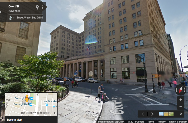
Census block 360470009001004 (that’s a FIPS code; “36” is New York “36047” is Kings County, and so forth) is in Brooklyn, between Court St and Adams St and between Livingston St and Joralemon St. The Borough Hall metro station is on the northern edge of the block. (Find it on the Census Block maps here). A glance at Google Maps shows that this block is home to the Brooklyn Municipal Building, Brooklyn Law School, and a couple other buildings.

brooklynbridge

360470009001004

What’s special about census block 360470009001004 is that it supposedly hosted 174,000 jobs in 2010, according to the LEHD Origin-Destination Employment Statistics (ny_wac_S000_JT01_2010.csv). This caught my eye because it’s the highest level in New York and really, really high. The other ten census blocks contained in the same census tract (36047000900) have less than 15,000 jobs collectively. This would be a startling geographic discontinuity in employment density. The census block with the second highest level of employment in the entire state of New York has only 48,431 employees.

A glance at the Brooklyn Municipal Building shows that it’s big, but it sure doesn’t make it look like a place with 174,000 employees.

municipalbuilding

And other data sources that do report employment levels by establishment (rather than state employer identification number) show that there aren’t 174,000 jobs on this block. County Business Patterns, a data set that is gathered at the establishment level, reports that total paid employment in March 2010 in ZIP code 11201, which contains this census block and many others,  was only 52,261. Looking at industries, the LODES data report that 171,000 of the block’s 174,000 jobs in 2010 were in NAICS sector 61 (educational services). Meanwhile, County Business Patterns shows only 28,117 paid employees in NAICS 61 for all of Brooklyn (Kings County) in 2010. I don’t know the details of how the state UI records were reported or the geographic assignments were imputed, but clearly many jobs are being assigned to this census block, far more than could plausibly be actually at this geographic location.

So you need to be careful when you zoom in. Robert Manduca’s map happens to not be too bad in this regard, because he limits the geographic resolution such that you can’t really get down to the block level. If you look carefully at the image at the top of this post and orient yourself using the second image, you can spot the cluster of “healthcare, education, and government” jobs on this block near Borough Hall just below Columbus Park and Cadman Plaza Park, which are jobless areas. But with 171,000 dots on such a tiny area, it’s totally saturated, and its nature as a massive outlier isn’t really visible. In more sparsely populated parts of the country, where census blocks are physically larger areas, these sorts of problems might be visually evident.

“Where Are The Jobs?” is an awesome mapping effort. It reveals lots of interesting information; it is indeed “fascinating” and contains “incredible detail“. We can learn a lot from it. The caveat is that the underlying data, like every other data source on earth, have some assumptions and shortcomings that make them imperfect when you look very, very closely.

P.S. That second-highest-employment block in New York state? It’s 360470011001002, across the street from the block in question. With 45,199 jobs in NAICS sector 48-49, Transportation and Warehousing. But all of Kings County reported only 18,228 employees in NAICS 48 in 2010 in the County Business Patterns data.

“Large cities” in the EU and US, redux

The Economist is six months late to the party, but the latest print edition has a piece on that McKinsey comparison of American and Europe cities. I have some quibbles, again.

I don’t understand the piece’s opening, though it has little to do with what follows. It begins:

AMERICA is full of vast, empty spaces. Europe, by contrast, seems chock-a-block with humanity, its history shaped by a lack of continental elbowroom. Ironically, Europe’s congestion partly reflects the fact that its large cities suck up relatively few people.

Moving people across cities wouldn’t change the (unweighted) average population density of the US or EU, so what does this comparison mean? Europe is going to be full of humanity because the land area of the EU is roughly half that of the continguous US (1.7m vs 3.1m square miles). Since larger cities are generally denser, the population-weighted density of Europe would rise if its large cities had higher population shares.

Never mind the elbowroom. The Economist continues:

Although America and the euro zone have similar total populations, America’s 50 largest metropolitan areas are home to 164m people, compared with just 102m in the euro area. This striking disparity has big consequences.

Differences in metropolitan populations may help explain gaps in productivity and incomes. Western Europe’s per-person GDP is 72% of America’s, on a purchasing-power-parity basis. A recent study by the McKinsey Global Institute, the consultancy’s research arm, reckons that some three-quarters of this gap can be chalked up to Europe’s relatively diminutive cities. More Americans than Europeans live in big cities: there is a particular divergence in the size of each region’s “middleweight” cities, those that teem just a little less than the likes of New York and Paris (see chart). And the premium earned by Americans in large cities relative to those in the countryside is larger than that earned by urban Europeans.

As I explained back in April, the MGI report does not say Europeans would reach American prosperity levels if the population shares of their large cities reached American levels:

The gap in per capita GDP between the US and Europe is about 35%, according to the MGI figures in Exhibit 2. The “large city” premia in the United States and Europe of 34% and 30% are virtually the same. That means that the difference in per capita income attributable to the difference in “large city” population shares is the large city premium (~30pp) times the difference in large city population shares (22pp). The six to seven percentage points explained by this difference in population shares is at best one-fifth of the 35% gap between US and EU incomes. You can confirm this quick calculation by studying the decomposition in MGI’s Exhibit 2. Moving more people into large cities wouldn’t meaningfully reduce the US-EU per capita income gap.

Look at Exhibit 2 for yourself:

The Economist mentions the big-city population share and big-city premium components. They neglect that 53 of those 74 percentage points are strictly attributable to the difference in average income. Differences in metropolitan populations are not at the heart of the story.

After citing all the advantages of cities, the Economist considers two reasons why European cities aren’t as large as US cities: regulatory barriers and incomplete integration. While the former might matter, I put a lot of stock in the latter. As I explained in my prior post, Zipf’s law holds at the country level. Since no European state has a population close to 300 million, we should not expect any European city to approach the size of NYC or LA. Until intra-European mobility looks anything like intra-US mobility, I think we should expect Zipf’s law to hold at the country level. And since MGI used a common cutoff of population > 150,000 for defining a “large city”, it’s not at all surprising that a larger share of the US population lives in its large cities. I wrote before:

Given the UK population, increasing the fraction of UK residents who live in “large cities” with populations greater than 150,000 would require the emptying out of smaller metropolitan areas. While such migration is entirely possible, it would violate the expected city size distribution… If you know the populations of New York and London and are familiar with Zipf’s law, then it’s not at all surprising that a greater fraction of the US population is found in metropolitan areas above some common population threshold. I don’t think that tells us much about the economic mechanisms determining the role of US cities in the global economy.

Update: Related to my comparison of US and UK city-size distributions, see Henry Overman on the details of Zipf’s law for UK cities.

Cross-country comparisons of large cities

A number of people have highlighted a new McKinsey Global Institute report on US cities in the global economy.

Here’s the MGI summary:

In a world of rising urbanization, the degree of economic vigor that the economy of the United States derives from its cities is unmatched by any other region of the globe. Large US cities, defined here as those with 150,000 or more inhabitants, generated almost 85 percent of the country’s GDP in 2010, compared with 78 percent for large cities in China and just under 65 percent for those in Western Europe during the same period. In the next 15 years, the 259 large US cities are expected to generate more than 10 percent of global GDP growth—a share bigger than that of all such cities in other developed countries combined.

I find this definition of a “large city” to be puzzling. I’ve searched the report for the word “150,000” and the authors don’t seem to have provided an explanation for this measurement choice. That’s unfortunate, because using this cutoff for cross-country comparisons has big implications that may lead readers astray. But before we get into those measurement details, let’s just make clear what the report’s executive summary does and doesn’t say.

At Ezra Klein’s place, Brad Plumer says:

The report’s authors argue that the city gap between the United States and Europe account for about three-quarters of the difference in per capita GDP between the two. In other words, the United States appears to be wealthier than Europe because it has a greater share of its population living in large, productive cities.

That second sentence isn’t plausible. Look at Exhibit 1 in the McKinsey report, which I’ve reproduced here:


The gap in per capita GDP between the US and Europe is about 35%, according to the MGI figures in Exhibit 2. The “large city” premia in the United States and Europe of 34% and 30% are virtually the same. That means that the difference in per capita income attributable to the difference in “large city” population shares is the large city premium (~30pp) times the difference in large city population shares (22pp). The six to seven percentage points explained by this difference in population shares is at best one-fifth of the 35% gap between US and EU incomes. You can confirm this quick calculation by studying the decomposition in MGI’s Exhibit 2. Moving more people into large cities wouldn’t meaningfully reduce the US-EU per capita income gap.

Over at Atlantic Cities, Nate Berg summarizes Exhibit 1 as “though cities all over the world are responsible for major contributions to the global gross domestic product, the concentration of large – and especially semi-large – cities in the U.S. outperforms them all.” He quickly notes that “the sheer number of large cities in the U.S. is clearly a major part of the difference, especially with about 80 percent of the country’s population concentrated in these metropolitan regions.” In fact, it’s more than a major part of the difference – it’s basically all of it.

“Large city” economic output is a larger share of total economic output in the United States because “large city” population is a larger share of population in the United States. US “large cities” have 80% of the US population and produce 84% of US output. European “large cities” have 58% of their population and produce 64% of their output. If “large cities” are more important to GDP in the United States (or in Plumer’s interpretation the US “derives more economic benefit from its cities than any other country on the planet”), it’s because a larger fraction of the population lives there.

This is a statistical artifact created by using the same population cutoff to define “large cities” in countries with quite different national populations. It’s not clear that telling us that a greater share of Americans live in metropolitan areas with populations greater than 150,000 than Europeans tell us that these economies operate differently.

The typical country’s city size distribution is decently characterized by a power law, Zipf’s law, which implies a log-linear relationship between a city’s size and its rank in the size distribution. Zipf’s law doesn’t hold for the entire distribution, but we know from Rozenfeld, Rybski, Gabaix & Makse (AER 2011) that it’s a decent approximation for places with more than 10,000 or so people in both the US and UK.

I’ve displayed the city size distributions for both the US and UK in the figure below. The US distribution stops around 10.8 because only 280 (consolidated) metropolitan areas were defined in 2000. Rozenfeld et al have shown that it’s safely to linearly extrapolate down to something like 9.4.


Given the UK population, increasing the fraction of UK residents who live in “large cities” with populations greater than 150,000 would require the emptying out of smaller metropolitan areas. While such migration is entirely possible, it would violate the expected city size distribution. We don’t see such top-heavy city size distributions in economies with a decent number of cities (of course, city-states like Singapore violate Zipf’s law). If you know the populations of New York and London and are familiar with Zipf’s law, then it’s not at all surprising that a greater fraction of the US population is found in metropolitan areas above some common population threshold. I don’t think that tells us much about the economic mechanisms determining the role of US cities in the global economy.

Addendum: The MGI report compares Western Europe to the United States, but Zipf’s law holds at the country level. Using Western Europe, which has an aggregate population akin to that of the US, doesn’t give us reason to expect  a similar share of the population to live in cities with populations exceeding 150,000. There is no Western European city the size of Los Angeles or New York. [Thanks to @ptitseb for suggesting this clarification.]